Repatriation is probably one of the most contested and emotive issues within heritage. It comes with far more questions than it ever does answers, yet for a paper I about to write as part of a course I'm currently doing I am seeking for answers.
The question I have is so broad the 2500 words seems like it can only ever be an introduction! After completing a fair bit of background reading I still do not know if I fully agree or disagree with the notion. I have however reduced it down to human remains and more specifically of ancient Britons. There seems to be a lot of focus on the repatriation of indigenous peoples and rightly so, but, I have found very little on the repatriation of Britons from Britain's museums. There are Pagan and Druid groups that are making calls for museums to return Britons to their locales and to be re-interred. However, this has problems of its' own, from where to place them, how to place and what sort of ceremony should occur. I can't even decide when the term ancient Briton no longer applies!
As you can see I have found myself a mine field, but, I am not put off by it! Instead I thought I would try and gather the thoughts of others, so it is over to you...if you have strong views, good articles, case studies anything at all really get in touch and broaden my horizons.
Looking forward to hearing from you all :0)
Showing posts with label Iron Age. Show all posts
Showing posts with label Iron Age. Show all posts
Sunday, 17 March 2013

Monday, 17 December 2012
A Time for Sharing...
Today's artefact is one that symoblises two things; the social nature of food consumption and the best wetland Iron Age site in England....

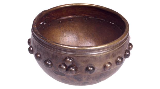
Image taken from the BBC
It is the lovely Glastonbury bowl! This bowl is probably one of the best known artefacts from the assemblage discovered at The Glastonbury Lake Village. The Village is thought to have been established in c.300BC and had declined by 100AD to the point of disuse. The Village was built upon a wooden platform and formed an artificial island in a peat bog, known in my part of the world as a Crannog. It is thought by 100AD the water levels had raised so high that the site had to be abandoned and as such it was quickly lost. Until 1892 when Mr Arthur Bulleid discovered the Village, though excavation was conducted until 1892. During this excavation much of the Village was unearthed and the wood was in extremely good condition, knowing that the peat and water was required to keep the Village it was reburied and studied from field notes and artefacts that it was safe to remove. On the whole the site and its' artefacts are cared for by The Glastonbury Antiquarian Society, founded by none other that Bulleid. They ensure the site is kept wet and run a small museum to display the many artefacts. This bowl is a beautiful example of Iron Age craft and serves as a reminder of day to day life and the need for food; however the ornate pattern and attention to detail may be an indication of more than the need for a bowl. I'm sure many of you have used a bowl today, but none quite as fancy I'm guessing? The decoration and material suggest that the consumption of food was a public affair in this Village, may be only certain times a year, but public none the less. Been as we are in the festive period it is easier to consider the social importance of consuming food. It is present at most parties and gatherings, we feel the need to prepare our own food more at this time of year, little things like making our own cake, pastry or pie, that we may be wouldn't do other times of the year...why? Because Christmas is special, it's the time of year we let people know how important they are and by making our own foods it's a way of expressing it, through the act of sharing what we have. There is nothing to suggest that a similar psychology wasn't present in Iron Age Britain, it wouldn't have been for Christmas, but, it may have been for the Winter Solstice. This bronze bowl is a good example of an artefact that, with a little thinking outside of the immediate box, can provide us with more information than functional activities.
Friday, 14 December 2012
Perfect Pots
Today's artefact is a particular favourite of mine and has featured within work I have conducted...

Image taken from Moody. G. 2008
The
Isle of Thanet from Prehistory to the Norman
Conquest Stroud: The History Press

This beautiful urn was discovered in Margate, Kent in 1924 by Arthur Rowe, he suggests in his recordings that the urn was restored, but as you can see from the image it is difficult to see where this occurs. The urn is a dark grey colour, almost black in
terms of the face, with the inner colouring slightly lighter. It measures some 17.5cm at the widest
surviving point, with a mouth diameter of c.12.5cm. Where measurable the urn is c.5mm thick and
this appears to be consistent. Under the
neck there is a groove, this runs around the urn at a consistent distance from
the rim and above a punctured ‘dot’ pattern.
Further to this the urn is decorated with curved ‘leaf shape’ pattern,
marked out with a groove and in filled with further puncturing. This appears distinctly La Tène I in nature. Whether the urn was made in Thanet or imported cannot be determined within the available literature, but either way it suggests a strong and developed link between Margate and areas such as the Rhine. There is a suggestion that it was wheelmade, largely due to the consistency in thickness. Its' discovery in a Middle Iron Age contexts means for this to be the case it must be imported as the technology does not reach Britain until the Late Iron Age. The connection with the Rhine suggests the importance of waterways in communication, trade and exchange; it was clearly central to Iron Age life and is beautifully represented within this urn. This urn is without doubt one of my favourite artefacts, it represents all that I understand of Middle Iron Age Thanet and is a symbol of the connected world I believe the Britons were a part of.
Monday, 10 December 2012
An Iron Age Weekend
Hello everyone, I was away for the weekend and had posts all set-up ready to go live by themselves, but technology failed me....so here they are!
December 8th
War, Peace or Other
Today we have an artefact that almost always immediately shouts of war....


December 8th
War, Peace or Other
Today we have an artefact that almost always immediately shouts of war....

Image taken from Shropshire Council
It's the Jackfield Sword, found in the River Severn, near Telford in the 1970's. The sword dates to the Early Iron Age and is a relatively rare find, made of bronze. The sword is leaf shaped and in beautiful condition considering it's age. The hilt is missing, but the fittings are in place, suggesting that it was made of organic material. It is likely that the wood or bone would have been carved in order to enhance the aesthetic appeal of the sword. During the Early Iron Age there is little evidence for warfare and the deposition of this sword in a river furthers such notions. It is one of a number of bronze and iron artefacts that have been found in watery deposits and as such it is believed that they have a ritual significance, potentially relating to a lost cosmology. It is often said that ritual is used by archaeologists as a means to avoid artefacts and sites that do not fit into our plans, however, there surely had to be a level of belief and tradition. It features in cultures all over the world, so why not in prehistory?
December 9th
Today is the turn of something a little bit different....

Image taken from Portable Antiquities Scheme
It is the beautiful Tanworth Comb, discovered in Warwickshire, 2006. Finds like this traditionally would be lost to the record, until the Portable Antiquities Scheme came to being. This comb is a metal detecting find and its' finder did the right thing in taking it for study and identification. It is dated to the very end of the Iron Age or very early Roman Period. The comb is made of copper alloy, with both the front and back decorated with a detailed pattern. Through study it has been determined that the decoration was cast rather than added after the creation process. The teeth of the comb are fairly wide apart which suggests that it was not meant for human hair, but, instead it may be for the grooming of animals such as horses. This is another rare find and serves as a perfect example of what can happen when the world of archaeology and the metal detectoring enthusiasts come together. It also featured on Britain's Secret Treasures, Summer 2012.
Thursday, 6 December 2012
Fabulous Fashion...Iron Age Style
Today I have for you a fashion must have, forget Tiffany's it's all about the shale ladies (and gents).


Image taken from Glasgow Museums
This particular example was discovered in a churchyard in, Portpatrick, Scotland. It is currently held by Glasgow Museums; however it sadly does not feature in a display and is currently in storage. Whether you want to call it a bracelet, a bangle or an armlet its' beauty is timeless. This example is thought to be Iron Age but it is possible that it was Roman.
Shale bracelets have been a must have accessory since the Bronze Age and areas such as Kimmeridge, Dorset were centres of production. Their frequency across Britain is testament to the trade routes that were utilised in Prehistory. The production of such artefacts left an inner shale disc, perfectly formed with a slight dent in the centre, these were so frequently discovered in the Dorset region that they were initially thought to be an early currency. This example is rare as it is completely in tact, they are usually discovered in a fragmentary condition and this is likely to have helped the formation of the currency theories. The work that went into its' creation is clear to see, they are always perfectly rounded, smooth and still polished to a point that after the mud is wiped away they shine like they were made that morning. It is hard to know who wore them or why! They pop up everywhere, in contexts associated with both genders and some are so small they are potentially for children. I would not say that they were a practical item, more an item of adornment, but, their presence within the archaeological record suggests that they were treasured items and well curated by their owners. They have always amazed me, always a piece of prehistoric perfection.
Monday, 3 December 2012
A little bit of bling....
Today I have a rather special little something....The Broighter Boat!


Image taken from www.100objects.ie
This beautiful gold boat is a particular favourite of mine and until very recently I thought it was an isolated find, however, it was in fact, part of a gold hoard dating to the first century BC. This is by far the shining light of the deposited artefacts and now takes pride of place in the National Museum of Ireland. The hoard was found near Limavady, Northern Ireland in 1896 by Tom Nicholl, interestingly Belfast only holds replicas of the hoard and this particular artefact does not feature in the Ten Major Pieces (as chosen by National Museum of Ireland).
The boat is modest in size reaching c.18cm in length and some c.7.5cm in width. Despite this it is the best known model of a vessel of the period, particularly one that is truly sea-worthy. In reality wood is the most likely material of construction though hide may be possible. The Broighter Boat is complete with oars, two sets of 9, with 8 benches present. It is thought that a bench may be missing this making it possible that 18 people we required to power a presumed real version. The vessel also has a rudder allowing for control and tools were also found with it relating to grappling. There were also 3 forks, a spear and a yardarm. The details contained within the boat make it highly desirable for study into prehistoric vessels and the potential they had for trade and population movements...I certainly wouldn't say no! But it also illustrates the skills of the metalworkers involved and the importance of the piece. The fact that this little boat survives so well is testiment to it being part of a hoard, I am of the belief it was made to be buried, possibly to please an Irish water deity such as Manannán mac Lir.
I hope you have enjoyed the Broighter Boat as much as I do, but today I have a little bonus for you, particularly Iron Age fans....Many of you may have seen posts relating to an Iron Age helmet and associated brooch and spike, but for those that haven't I wouldn't want you to miss out so be sure to visit Annie at: http://beadsboatsandflowerbeds.blogspot.co.uk/
Sunday, 2 December 2012
Archaeology Advent...
Christmas is fast approaching so I thought it was only right to get into the spirit of the season....but with an archaeological twist! So here is the first instalment of my archaeology advent calender. So how will it work I hear you cry...well everyday on the run up to Christmas I will share a beautiful artefact with you all. I know it's starting a day late so today you get two, you lucky things you!
So December 1st.....


This beautiful button scraper was discovered within the Great Carn, Cefn Bryn, (Gower, South Wales) during excavations between 1983-1985 under the watchful eye of Dr Anthony Ward. It was brought to my attention during my studies in Kent, when I studied the lithic assemblage. This scraper was my favourite from all of the diagnostic period, so I wanted to share it with all of you. It's tiny, yet perfectly formed. It was worked on all faces, however, it was discovered within the spoil heap, so in terms of site interpretation it is limiting.
December 2nd......

Be sure to check back tomorrow, who knows what you might discover.....
So December 1st.....


This beautiful button scraper was discovered within the Great Carn, Cefn Bryn, (Gower, South Wales) during excavations between 1983-1985 under the watchful eye of Dr Anthony Ward. It was brought to my attention during my studies in Kent, when I studied the lithic assemblage. This scraper was my favourite from all of the diagnostic period, so I wanted to share it with all of you. It's tiny, yet perfectly formed. It was worked on all faces, however, it was discovered within the spoil heap, so in terms of site interpretation it is limiting.
December 2nd......

Taken from www.bbc.co.uk
For today we have the Capel Garmon Firedog, a beautiful example of Iron Age metal working. The firedog is usually utilised in pairs and is associated with the hearth and cooking cauldrons of the period. The condition of this example is spectacular and as such it was likely deliberately placed within the ground. The firedog is now housed within the Origins Gallery of the National Museum Wales, Cathays, however it likely to see a move to St Fagans, National Museum of Welsh History in the near future. I feel that this artefact speaks for itself so rather than waffle on I shall leave you to admire it.Be sure to check back tomorrow, who knows what you might discover.....
Thursday, 22 November 2012
North Foreland
What seems like forever ago I told you all about Mysterious
Margate, so now as promised it is the turn of North Foreland. For those not in the know, North Foreland is
an area within the locality of Broadstairs.
It has a well defined Iron Age past and provides a nicely sized area for
discussion. There are several sites for
us to explore; St Stephen’s College (Boast et
al 2006), Stone Road (Moody 2005a), Bishops Avenue/Hamilton Lodge (Moody
2005b), Lanthorne Road (Hurd 1913), Albert Lodge (Hart 2006a), Castle Keep
Hotel (Hart 2006b) and ‘Beauforts’ (Hart 2005).
St Stephen’s College (Boast et al 2006)

St Stephen's College, site plan, The North

St Stephen's College, Site Plan, The South
This site is particularly complex so we will approach it one
phase at a time. It is rich in Iron Age
archaeology and the principal features consist of post built structures, linear
features (including 50 post holes), rectilinear enclosures and a number of
pits.
Phase 1
This phase dates to c.500-300/250BC so can be characterised
as being Middle Iron Age in nature. It
was suggested by Boast that the sporadic nature of the features may mean that
this was a seasonal site. There are
several large, air-tight storage pits which bolter this theory as they are
likely to have contained foodstuffs.
They provided an area of storage away from the nucleated settlement;
however I am unsure as to the seasonality of their use. The area in which they are located has soil
well suited to growing crops and an expanse of land that can be used for animal
husbandry, it therefore seems as though seasonality in this instance leads to a
waste of land. The climate remains
constant across the Isle and as such there seems little reason for the site to
be undesirable at any given period of the year.
Environmental sampling suggests that the level of chaff present is
consistent with cereal processing, thus meaning that the site may be related to
industry. This is enhanced from the
variety of animal bones that are present; the sample is indicative of animal
husbandry rather than feasting. A
further point of interest is the presence of marine shell. Within Britain
The pottery assemblage for this phase enhances the link the
residents had with the sea. There are
several examples of localised pottery; however, there is a strong Continental
flavour. The highlight of this is a
sherd from a vessel which has distinct parallels with those known at
Neuville-sur-Escaut, particularly around the 450-300BC mark. Along with the ceramic evidence noted at
Hartsdown, Margate , it is becoming increasing
clear that Middle Iron Age Thanet had strong Continental links, despite it
generally being accepted that Britain
There is also burial evidence for this period, firstly in
Pit 4228; sadly this is the final resting place of a neonatal, this can often
be interpreted as infanticide, however, I do not feel this is the case in this
particular instance. The site is also
the resting place of an individual with unilateral ankylosis; this means the
person in question would experience a great deal of discomfort when pressure
was applied in the mouth. The result
would be that large pieces of food and meat in general may have been
particularly difficult to consume. The
survival of the individual into adult life suggests a tolerant and
compassionate society, willing to care for others and assist them with their
needs. I therefore question why they
would practice infanticide and conclude that the neonatal remains were a result
of nature’s cruelty as oppose to that of society.
Phase 2
Broadly speaking this phase encompasses c.300/250-50BC, there
is some overlap with Phase 1, but it interestingly ends before the Roman
invasion. The principal features
relating to this phase is an enclosure running parallel to a hollow way and a
50 post palisade. The interpretation of this
phase is debated, but, on initial observation I sided with a cattle kraal,
until I looked deeper. The cattle kraal,
for me, was certain from the palisade and the formation of an extensive
boundary, however, pottery found within the post holes was of an Early Iron Age
nature. This makes me doubt the cattle
kraal theory, but at the same time I am not ready to embrace the enclosure as
being a defended enclosure for times of trouble. Firstly the enclosure is only 0.1ha, which I
feel is too small an area to sustain a community, secondly there is limited
evidence that such a protective enclave would have been required. Further to this there are limited 4 and 6
post structures, so where would people have sheltered? These structures are interpreted in the report
as being granaries; this would be in keeping with a potential defended interior,
however in this case I do not think it is the case. Instead I propose that these structures are
in fact housing, there is a distinct lack of roundhouses upon Thanet, this is
possibly due to ploughing and the loss of the tell tale drip gully. I however believe that it may be a case that
they were never there in the first place.
Instead I think that the population of Thanet lived it houses similar to
those on The Continent, this would mean they would leave rectangular traces
consistent with the long-house culture.
If the 6 post structures are related to dwellings, those
that are 4 post may well be granaries, but why would one nucleated settlement
need so many and why would they be enclosed?
Maybe this relates to the economic expansion of the area, possibly even
by the decedents of those in Phase 1.
Increased production, would require increased storage, perhaps the
dwelling was that of a merchant, a trader, even an Iron Age entrepreneur? Okay so maybe an entrepreneur is pushing it
and I should watch a little less of The Apprentice and the Junior version, but,
I hope you are following my point! I
believe this enclave to be a centre for trade, whether there was power for the
people who may or may not of lived there I do not know and I am not overly
concerned by it either. What I do know
is nearby a potin coin hoard has been found, the original Phase 1 site has
seemingly progressed and the levels of external influences speak for
themselves. The pottery assemblage is
key to this; Flanders ’ La Tène III inspired
pottery is present, particularly the S-profile noted on a number of locally
produced sherds. This suggests prolonged
contact with the Continent, the pottery of Flanders
is considered to be so accepted that it was becoming a feature of Late Iron Age
Thanet. People were so accepting of it
that it had almost become their own.
There is also evidence for pottery indigenous to more localised regions,
with several sherds consisting of fabrics associated with Folkestone. This suggests a level of contact with East Kent;
however, it is notably rare in comparison to vessel sherds inspired by Flanders .
So far, St Stephen’s College is depicting the region as
being affluent, secure, complex and economically developing, while highlighting
a community that was able to trade and demonstrate compassion.

Stone Road, Site Plan
This site does not demonstrate the richest collection of
Iron Age features, particularly in terms of occupation evidence. However it remains of interest.
Firstly I will discuss the presence of a high number of
animal bones. The species present
included cattle, sheep/goat, pig, dog and horse. A study was conducted to determine if the
bones were evidence of a butchery site, due to such high volumes. The study concluded that the gnawing was
consistent with general domestic consumption and the notions of wide scale
butchery are quickly lost. However,
there is a distinct lack of domestic occupation evidence; the site lacks pits,
linear features and post holes.
The site did produce further features, most of which are
Roman and are found much higher than the numerous bones, so it is safe to
assume that they are unconnected. The
site does contain 6 prenatal inhumations, each with sherds of Late Iron Age
pottery, which acts as dating evidence.
These inhumations are truncated by Roman features, so it can be assumed
that there was no settlement present when Roman construction began. The graves were presumably unmarked to the
invaders eye, or it is unlikely that they would have been disturbed. The presence of pottery and the nature of the
burials are indicative of deliberate acts, suggesting that it was a form of
traditional practice, at least in this region.
It is possible that the site is at the edge of a Late Iron Age burial
ground, but what about those bones? Well
there is plenty of evidence of feasting at Iron Age funerals, so why should
these 6 tiny individuals be any different; time had been taken to bury them, so
surely they would have received all rites.
Bishops Avenue/Hamilton Lodge (Moody 2005b)

Bishops Avenue, Site Plan
This site dates from the Middle to Late Iron Age and
consists of linear ditches and 4 post structures. The fill from the linear ditches yielded high
amounts of faunal remains and as such comparisons have been made to Stone Road
Despite the presence of structures and animal bone, there is
very little in the way of material culture.
28 sherds of a single rusticated storage jar, with parallels to those
found in Ebbsfleet, were discovered at date to c. 500-300BC. This gives the earliest date for potential
landscape use; however, due to the amount of the vessel that survives it is
potentially a deliberate deposit. There
is little else to suggest a hoard, just a single vessel in an unusual
location. There are several sherds of
Later Iron Age pottery associated with the 4 post structures, suggesting that
they are secondary to the activity relating to the rusticated storage jar. There is also a single potin coin,
c.150-50BC, but it is unlikely that this is representative of anything more
than casual loss.
I have already mentioned the faunal comparisons and the
findings are supportive of the limited material culture. The bone assemblage at this site is in far
poorer condition than those at Stone
Road Bishops Avenue
This excavation took place in the early 1900’s and there is
little in the way of a record and definitely no site plan. I have included it though…you are probably
wondering why, while thinking I may have gone a touch mad, but there is a
method…I promise!
All that was recorded was the discovery of a vessel; it was
black ware, local and nothing particularly special. It was decorated with ‘nail marks’ and had
some comb detail on a number of sherds.
Its interest comes with its parallels to vessels in Dumpton, hardly a
million miles away I know, but when I couple it with a mixture of faunal
remains and geographical positioning, I think it gets interesting. During this time Thanet, much like today, had
a network of tracks. Some of these we
know, whereas other areas seem isolated, this is one of those. The evidence is suggestive of a route way
that we were possibly unaware of, this is very tentative and possibly
circumstantial, but considering the high presence of potin coins in the area,
entirely possible. North foreland lacked
a sea connection, but Dumpton did not…see there is some method!
Albert Lodge (Hart 2006a), Castle Keep (Hart 2006b) and
‘Beauforts’ (Hart 2005)
The location of these sites in North Foreland, made me
certain when I picked up the reports that I would find more archaeological
gold…but there was nothing, not a single Iron Age sherd, not one tiny coin, not
even a post hole. Either this was not
the place to be in Iron Age Thanet, or something is a miss. Well I’m going with the latter…I do not
believe that nothing happened here, in such close proximity to other evidence,
instead I think it is lost. This area
has been agriculturally significant for hundreds and hundreds of years and it
has been a desirable spot for construction.
So, imagine the amount of ploughs that have turned that soil, the amount
of holes dug for foundations. Now
consider how our post holes, pits and ditches would survive it. It is hardly surprising that we have a
feature free zone. I have included this
to make the point that a lack of evidence is not always evidence for a lack of
landscape use…an important archaeology lesson!
What does all this mean?
Well unlike Hartsdown, North Foreland is complicated and
little bit messy. It clearly saw Iron
Age life, definitely in the Middle and Late periods and we know the Romans
found it too.
From the evidence we have seen it seems that St Stephen’s
College was the place to be, it was multi-phase and expanding, suggesting a
strong and stable economy. The presence
of Continental material culture and inspiration was clear and life was
seemingly good. However, it is difficult
to place Stone Road Bishops Avenue Stone
Road Bishops
Avenue
The next area I will explore is Central Broadstairs, but be
sure to keep North Foreland in mind while reading…I have a feeling it has a lot
more to offer.
Until then keep exploring
and keep in touch via Facebook, Twitter and email: musingsofanunemployedarchaeologist@hotmail.co.uk
Infleuntial Reading
Boast et al. 2006 Excavations at St Stephen's College, North Foreland, Broadstairs Kent: Archaeological Excavation Report Thanet Archaeological Trust Unpublished
Hart, P.C. 2005 'Beauforts', North Foreland Avenue, Broadstairs, Kent: Archaeological Report Thanet Archaeological Trust Unpublished
Hart, P.C. 2006a Groundworks Associated with the Construction of a Swimming Pool at Albert Lodge, North Foreland, Broadstairs, Kent: Archaeological Watching Brief Report Thanet Archaeological Trust Unpublished
Hart, P.C. 2006b The Construction of a Block of 16 Self-Contained Flats, Former Castle Keep Hotel and Forelands, Joss Gap Road, Broadstairs. Kent: Interim Archaeological Watching Brief Report Thanet Archaeological Trust Unpublished
Hurd, H. 1913a; 1913b; 1913c. Some Notes on Recent Archaeological Discoveries at Broadstairs Thanet Archaeological Trust Unpublished
Moody, G 2005a Land to Rear of 103 Stone Road, Broadstairs, Kent: Archaeological Report Thanet Archaeological Trust Unpublished
Moody, G. 2005b Hamilton Lodge, Bishops Avenue, Broadstairs: Archaeological Report Thanet Archaeological Trust Unpublished
Infleuntial Reading
Boast et al. 2006 Excavations at St Stephen's College, North Foreland, Broadstairs Kent: Archaeological Excavation Report Thanet Archaeological Trust Unpublished
Hart, P.C. 2005 'Beauforts', North Foreland Avenue, Broadstairs, Kent: Archaeological Report Thanet Archaeological Trust Unpublished
Hart, P.C. 2006a Groundworks Associated with the Construction of a Swimming Pool at Albert Lodge, North Foreland, Broadstairs, Kent: Archaeological Watching Brief Report Thanet Archaeological Trust Unpublished
Hart, P.C. 2006b The Construction of a Block of 16 Self-Contained Flats, Former Castle Keep Hotel and Forelands, Joss Gap Road, Broadstairs. Kent: Interim Archaeological Watching Brief Report Thanet Archaeological Trust Unpublished
Hurd, H. 1913a; 1913b; 1913c. Some Notes on Recent Archaeological Discoveries at Broadstairs Thanet Archaeological Trust Unpublished
Moody, G 2005a Land to Rear of 103 Stone Road, Broadstairs, Kent: Archaeological Report Thanet Archaeological Trust Unpublished
Moody, G. 2005b Hamilton Lodge, Bishops Avenue, Broadstairs: Archaeological Report Thanet Archaeological Trust Unpublished
Saturday, 22 September 2012
Have you done your bit?
As I am sure many of you are aware a ridge near a hillfort in Sheffield is under threat, I urge you all to sign the petition if you haven't already done so. It is easy to think that it's not in your area so doesn't matter...however that could not be further from the truth. The ridge in question is poorly understood and is yet to have secure dating. By signing the petition to save it you allow for the potential of further investigations and studies to be conducted. It maybe argued that construction would allow for investigation; however the monument would be lost and could never be studied in conjunction with its wider landscape. The local and national significance of this ridge is unknown, however what is known is that it forms a piece of our historic puzzle...who knows what piece it may be.
https://www.change.org/en-GB/petitions/the-planning-inspectorate-refuse-planning-permission-to-build-houses-on-the-historic-roman-ridge-2
https://www.change.org/en-GB/petitions/the-planning-inspectorate-refuse-planning-permission-to-build-houses-on-the-historic-roman-ridge-2
Wednesday, 22 August 2012
Mysterious Margate
This one has taken a while to reach you and I can only
apologise for that. I have been
fortunate enough to be involved in some interesting, but time consuming,
projects of late and wanted to make sure that my Thanet research was done properly. I’ve been missing the Isle of late and
yesterdays Dreamland announcement gave me the blog nudge that I needed. I hope you have enjoyed my other bits and
bobs, but, now we return to the research that I was so frantically trying to
tie together this time last year…how time flies!
For those of you that don’t know

The top triangle marks the point of the Margate

The circles marked 1,2 and 3 provide a rough location of the
sites that will be considered, time will be spent considering their features,
finds and interpretations, before I give you a round up of Iron Age
Margate. (My apologies for the size of this image causing the post to become untidy, but it is the only way that numbers can be made out)
The Hartsdown area of Margate Tivoli Park (Perkins 1996), Hartsdown
Technology College
(Gardner and Gibbon, undated) and Hartsdown
Park
Early Iron Age (c800-500BC)
Middle Iron Age (c500-300BC)
Late Iron Age (c300BC-AD43)
Belgic Phase (c150BC-AD43)
As you can see these dates all overlap, this is because the
dates were not determined by the Britons themselves, instead they are decided
by those that study them. You may read
other texts, blogs etc that have a varied dating system to mine, I certainly
experience this during my research…but these are the periods I found to be most
frequently attested to within Thanet.
Firstly we shall investigate Tivoli Park

You maybe wondering why the area consists of 13 individual
sites while I am considering it as one, well the area was excavated as part of
the Community Woodland Project and was conducted through the use of test
trenches. What we see on the above site
plan is what was excavated and mapped.
It is estimated that we have only discovered approximately 2% of Tivoli Park
Early Iron Age activity appears to be directly following
activities undertaken within the Bronze Age; it was probably even conducted by
the same people. All that was likely to
have changed for them was the pottery they were using. Site 2 provides an area where a possible
wooden structure was situated, but, the lack of adjacent features suggests that
it was not used for settlement purposes.
There is a lack of ditches and pits associated with domestic sites. Further to this Early Iron Age material has
been found within ditches forming Bronze Age Barrows. With this in mind I would suggest that the
postholes found at Site 2 represent a structure that was in someway related to
the ritualised landscape of Bronze
Age Tivoli
Park Shottendane
River
In close proximity is Site 3, these interlocking
semi-circular structures are interpreted by Perkins (1996) as being animal
corrals of an Early Iron Age date. Much
like the structure in Site 2 it appears to be a particularly isolated feature,
this leads me to associate it more with a ritualised landscape than that of a
settlement. With the exception of
pottery the feature yielded little in the way of finds, this would make it an
extremely clean settlement and furthers my suggestion that it is related to
Bronze Age landscape.
Some 400m to the West is a sub-rectangular ditch enclosing a
posthole. The purpose of this is also ambiguous;
however, its location upon the natural ridge is unusual. It did contain sherds of Early Iron Age
pottery and has the potential to be associated with the Bronze Age
landscape. It does appear to be out of
use and not considered important by the Late Iron Age as it seems it has been
truncated by a ditch which forms an alignment with the known Late Iron Age
enclosure. This is unlikely to have
occurred if the inhabitants were consistent as they would be aware of a social
significance to the structure.
The centre of the Site Plan is the focus of Middle Iron Age
activity, more specifically Sites 5-9. This
covers some 200m of the entire excavated area, revealing features such as
rectangular enclosures, multiple ditches, clusters of postholes and pits
considered to be for storage purposes.
In my opinion this is strong evidence of a settled community, further
supported by the discovery of a shale bracelet, cowry shell and weaving comb
within Site 5, along with two spindle whorls in Site 7. Site 7 also yielded a fragment of an Early
Iron Age brooch, the occurrence of this could suggest that the settlement is
associated with features in Sites 2 and 3; however, a single fragment is not
enough to form an entire settlement. At
the very least I would expect a presence of contemporary pottery. Instead I would suggest that the brooch was a
treasure possession, possibly an heirloom which broke beyond repair.
Sites 5-8 appear to be on a varied alignment to that of Site
9, this is suggestive of two phases of construction or even two separate
communities. It is possible that the
natural ridge acted as a boundary marker for differing social groupings,
however, both Site 6 and Site 7 encroach this ridge. It is also likely that the settlement
stretches in both a Northerly and Southerly direction, suggesting that we only
have a snippet of the overall Middle Iron Age activity within the area.
Late Iron Age activity is present within the site but
limited in nature. Site 1 is a Roman
trackway, frequented with Late Iron Age pottery, suggesting its construction
was in fact earlier. This is also
supported by the presence of the Bronze Age Barrow landscape; they are known to
be located along trackways and are thought by some, including myself, to
provide a means of navigating wider landscapes.
Site 10 is also Late Iron Age in date, the purpose of the rectangular
enclosure containing two large pits is unknown, but it appears to face a
South-Easterly direction and extended investigation into that area may have
provided us with further answers. The
lack of extensive Late Iron Age material culture could mean one of two things
that the Middle Iron Age community curate their wares well or the site was
largely abandoned. I personally feel
abandonment is more likely, with the potential for a new occupation area to
have been constructed in an unexcavated area in close proximity to Site 10.
Now we turn our attentions to Hartsdown Technology
College

As the Site Plan indicates there are relatively few features
within this excavation and in comparison to Tivoli Park
The dating of this site is particularly problematic, its’
agricultural nature means that there is little need for material culture, at
least not in the forms that survive.
There is some material culture, which is of particular interest when
considering the nature of socio-economic trends. Within Pit 2009 a large amount of an
individual ring based vessel, of La Tène influence and possibly even of origin
was discovered. The vessel dates loosely
to the 5th-4th centuries BC and as such tentatively dates
the field system. There is also some
evidence of contemporary fine and coarse wares, which could be indicative of
more than a field system. When this is
taken into consideration with the crouch inhumation located within the large
ditch of Enclosure 1 a clearer picture maybe painted. The style of the inhumation is contemporary
with both the La Tène influenced vessel and the other known pottery; it is
therefore possible that despite varied location they are associated with the
burial of the individual.
Interestingly the La Tène vessel was not the only object
yielded by Pit 2009; it also provided two awls and an annular brooch fitting. The awls are known to be of Early Iron Age
date, but, were also used within the Bronze Age. The annular fitting has not previously been
attributed to an Iron Age context and Gardener and Gibbon (Undated) suggest
that the objects were deliberately deposited in this location. They further this by noting that they are
related to the inhumation, however, if this were to be the case the objects
would have had to have been passed through several generations, this I feel is
unlikely and instead the items placed within a Late Bronze/Early Iron Age
context, likely to be in relation to the Bronze Age hoarding tradition apparent
across Thanet. It is possible that upon
burying the known individual these items were disturbed and the La Tène vessel
placed as an additional offering.
The final site to be considered is that of Hartsdown Park
What does this all mean?
Well firstly with some certainty I can say that the
Hartsdown area of Margate Shottendane
River
By the Middle Iron Age a well established settlement had
developed, this is potentially due to its’ proximity to a broad bay
harbour. The ability to access the sea
allowed inhabitants to access the world, well the Wantsum, Thames and North Sea at least.
Aerial photography has prompted discussions relating to larges ditches,
commonly associated with defended settlements; in this instance possibly a
promontory settlement, such as that suggested at North Foreland. This is supported by the inter-regional
connectivity demonstrated at both Tivoli
Park and Hartsdown Technology
College Northern Africa . The latter yielded a vessel of La Tène style,
this shows not only contact but lasting influence, suggesting that contact and
cultural exchange had been occurring over a longer period than we may have
originally thought. This illustrates the
importance of considering sites in conjunction with one another as oppose to
individually, it has allowed for a clearer image of the Middle Iron Age to be
produced.
For Middle Iron Age Margate to be receiving such commodities
it must have been providing something in return. This takes us back to the College, the environmental
samples coupled with the features points to an organised agricultural society,
working within a field system allowing for the production of surplus. Such surplus becomes as valuable as the grain
required for sustenance as it creates an economy which allows the community to
benefit.
By the Late Iron Age we appear to have a settlement shift
with the known Tivoli Hartsdown
Park
From our first set of case studies it is clear to see that Margate Margate
I hope you have all enjoyed our return to Thanet and her
beautiful Iron Age past, feel free to provide me with your thoughts and
suggestions on the material discussed in this post. As always it would be lovely to hear from you
all…so until we explore North Foreland, it’s bye for now :o)
Influential Reading
Boast, E. 2007. Bronze and Iron Age Occupation: Hartsdown Park, Margate in Archaeologia Cantiana Vol. 127 pp429
Perkins, D.R.J. 1996. The Trust for Thanet Archaeology: Evaluation Work Carried outin 1995, Hartsdown Community Woodland Scheme Margate in Archaeologia Cantiana Vol. 116 pp 265-281
Influential Reading
Boast, E. 2007. Bronze and Iron Age Occupation: Hartsdown Park, Margate in Archaeologia Cantiana Vol. 127 pp429
Perkins, D.R.J. 1996. The Trust for Thanet Archaeology: Evaluation Work Carried outin 1995, Hartsdown Community Woodland Scheme Margate in Archaeologia Cantiana Vol. 116 pp 265-281
Wednesday, 8 August 2012
An Adventure in Cornovii Territories...
What better way is there to spend a summer’s day than
exploring a hillfort? None…I didn’t think so! So this Silure ventured deep into
Cornovii territory to explore Old Oswestry Hillfort. Due to a few technical issues there are only
photos of the Southern end of the fort; it seems the Cornovii want the Northern
end to remain a mystery.

The above picture is probably my favourite of the day, it’s
the tour guides having a well earned rest! Along the Northern half of the
Hillfort the sheep graze freely and seem keen to show visitors the way to go
and even wait for you if you stop. Not sure if the Cornovii would have been quite
to welcoming to a Silure, or anyone else for that matter, this is one huge set
of defences after all. These lovely ladies greet you at the Western enterance and pretty much stay with you until you get to the Eastern enterance, then they cut through one of their many paths and rest on the second rampart.
English Heritage provides much information about Oswestry Hillfort so I won't go into too much detail here. My focus is largely on the original phase, which is the hillfort plateau, the first and second rampart and probably the entrence ways. The entrance to the East seemed to be situated slightly off the usual South-East axis that most hillforts conform to, this maybe a later edit to the monument, but, it seemed unlikely when assessing the ramparts.

This is the view from the top of the fort looking down the Eastern entrance way, as you can see the opening curves to the North, but, it then swings back to the South. It is now used as a passage way for cows, who very kindly let me stand amoung them to get this shot...I had to be extra brave! If the original entrance way swung back to the South I don't know, but that is the direction of the modern farm.
My last real observation, at least archaeologically speaking was an 'earthwork' to the South of the hillfort as shown below:


As you can all see, it's quite a substantial mound, but the trees hide the shape very well. This maybe a coincidence however, its' location and size have made me suspicious of its' origins. I haven't been able to find any information on the mound, but judging by the tree line it has an expansive flat area at the top. The upper image also shows signs of a second lower tree line, possibly indicative of a ditch. It is not unknown for Iron Age communities to occupy multiple earthworks within such close proximity, possibly accommodating a large population. I feel it is more likely to be for seasonal use, with their livestock benefiting from such structures during the Winter months, Summer uses is a little more ambiguous however!My last real observation, at least archaeologically speaking was an 'earthwork' to the South of the hillfort as shown below:


Overall Old Oswestry Hillfort is one of the best hillforts I have had the fortune to visit and I definitely recommend that if given the chance you all visit!
Rotten Romans in Wroxeter
I'm told all good things come to an end...well the Romans saw to that! I'm no lover of those pesky Romans and firmly believe that they should have stayed in Rome, but, just for a sunny July afternoon Wroxeter changed that! Another very well looked after English Heritage site and very reasonable entry prices too (always a bonus).The good old audio guide comes into its' own here, it allows you to take the site in on your own terms so you can do it as slowly or as swiftly as you like. I was shocked by how slowly I explored considering its' origins, but for the first time ever, I think I truly appreciated what it must have been like for the Britons when the Romans turned up. The monumental scale of Wroxeter's bath house really made me take a step back, the whole landscape would have become unrecognisable overnight...there is little wonder there was so much objection yet so much adaptation. Such changes must have been horrifying but at the same time mysterious.
Roman Wroxeter largely remains safely underground, the only section 'open' is the bath house and a small market place that was in such close proximity to the baths I would assume they worked hand in hand. Below shows a image looking across the site from just behind the short lived outdoor pool:

The surviving height of the structure shocked me, considering its' antiquity, but much of it is below floor level and demonstrates a beautiful hypercaust system:

The level of preservation is remarkable and as such in small areas there is Roman 'cement' still visible, I was slightly concerned that this can be walked over and is regularly and not always by children! In a similar fashion visitors spend a great deal of time sitting and standing on walls, so it remains to be seen how much longer it will remain in such lovely condition.
You may or may not know that the infamous Wattling Street ran through the center of Roman Wroxeter and still makes its' present felt today:

After crossing the road I was greeted by this...I'm sure you will agree its a pretty impressive building:

This was built by modern tradesmen using the techniques and technologies of the Romans. It was filmed and turned into a mini television series for Channel 4. I'm sure you all agree they did a marvelous job and can appreciate how excited I was to nose in a Roman Town house. I mean it isn't something you do everyday afterall....then I was greeted with this.....


Not exactly the Romano-British furnishings I was expecting! I can honestly say I have never been so disappointed with a heritage experience in my life....I was almost speechless! The work that has gone into the construction was truly let down by the lack of furnishing the town house. I was eager to have an archaeological experience that truly allowed me to appreciate the Roman use of space...it seems I will have to visit Pompeii afterall! This did not ruin my adventures in the lands of the Cornovii but it was definitely a long way from enhancing it. Much of the blame is to lie with English Heritage and the way they build the town house up to be such a beautiful reconstruction...which structurally it is, but it is hardly the full experience that is alluded to in advertisements, thankfully this was an addition to my adventure and not the purpose of it!

The image of the mosaic is by far the best from inside the house, it's such a sweet little thing, even if it is upside-down to the visitor. Hopefully one day the room will be dressed in a way that reflects his character and brings that added dimension to the town house.
I hope you enjoyed my little adventure and should you want to share a few of your own I would love to read them...you know where the comments box is :o)
Tuesday, 5 June 2012
Thanet Theory
Before diving straight into Isle Archaeology
My hypothesis is largely a revision of some and amalgamation of other theories that have already been discussed. The biggest change is probably my ideas relating to Core and Periphery...the principal has remained the same but the subjects have altered somewhat.

Starting with the 'Core' it is no longer to be seen as a settlement, or tribe or an individual location, instead it is water. Be it sea, lake, river, stream or brook, the waterways of the world are central to accessing landmasses. Through such waterways people, their produce, their belief, their ideas and their technologies travel, without them much of the Ancient World would have been isolated and society as we see it today would be consequently very different. It is important to remember that all waterways act as this 'Core', if we were to just consider the sea much of the world would remain in isolation. This makes the 'Periphery' land, not settlements, but actual land masses as shown in the image above. The settlements themselves are a product of the 'Core' and the 'Periphery'.
This basis allows for further developments in relation to Gateway Communities. Such an outlook of the world requires there to be numerous nodal points along the 'Core', acting similarly to the 'Inner Periphery' as described within the Central Place tab. This research aims to test the idea of Thanet being a nodal point, consisting of Gateway Communities. If this is to be the case, it is then to determine whose gateway it is, is it to Britain, the Near Continent or Both?
The next entry is to focus upon the archaeology of Margate...it will consider all phases of the Iron Age and pose questions and maybe answer a few!
My hypothesis is largely a revision of some and amalgamation of other theories that have already been discussed. The biggest change is probably my ideas relating to Core and Periphery...the principal has remained the same but the subjects have altered somewhat.

Starting with the 'Core' it is no longer to be seen as a settlement, or tribe or an individual location, instead it is water. Be it sea, lake, river, stream or brook, the waterways of the world are central to accessing landmasses. Through such waterways people, their produce, their belief, their ideas and their technologies travel, without them much of the Ancient World would have been isolated and society as we see it today would be consequently very different. It is important to remember that all waterways act as this 'Core', if we were to just consider the sea much of the world would remain in isolation. This makes the 'Periphery' land, not settlements, but actual land masses as shown in the image above. The settlements themselves are a product of the 'Core' and the 'Periphery'.
This basis allows for further developments in relation to Gateway Communities. Such an outlook of the world requires there to be numerous nodal points along the 'Core', acting similarly to the 'Inner Periphery' as described within the Central Place tab. This research aims to test the idea of Thanet being a nodal point, consisting of Gateway Communities. If this is to be the case, it is then to determine whose gateway it is, is it to Britain, the Near Continent or Both?
The next entry is to focus upon the archaeology of Margate...it will consider all phases of the Iron Age and pose questions and maybe answer a few!
Influential Reading
Birch et al. 1988 The Gateway Island: Archaeological Discoveries in the Isle of Thanet 1630-1987 Thanet District Council: Margate
Cunliffe, B. 2011 Europe Between the Oceans:9000BC-AD1000 Yale Press: New Haven and London
Fox, C. 1943 The Personality of Britain: Its Influence on Inhabitant and Invader in Prehistoric and Early Historic Times Fourth Edition. National Museum of Wales: Cardiff
Subscribe to:
Posts (Atom)